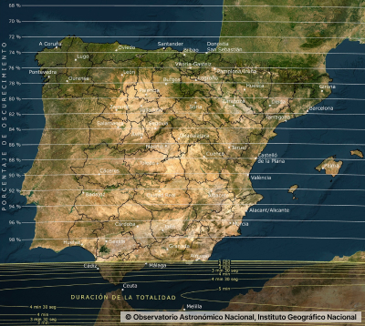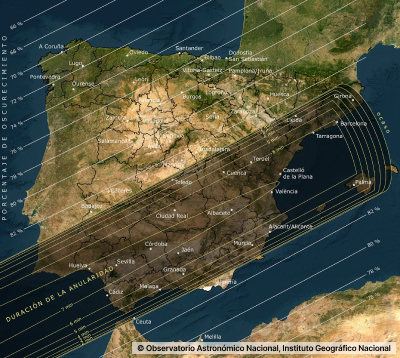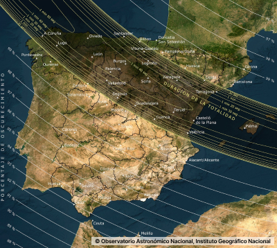
August 12, 2026
This section provides detailed information on the observing conditions for each eclipse at each geographical location in Spain, taking into account the terrain relief.
The data presented on this page use the method developed by Friedrich Bessel in the 19th century for calculating the global characteristics of each eclipse. Once this is done, local parameters are calculated for each location. Throughout this process, it is necessary to make approximations and apply different corrections to account for physical phenomena not included in the model.
When predictions from different sources are compared, small differences may appear in the eclipse parameters depending on the corrections applied and the precision used in the calculations. For the data provided on this page, calculations have been performed using double precision, and the following considerations have been taken into account:
The ephemerides of the Sun and the Moon have been obtained from the Jet Propulsion Laboratory, which provides the most precise data currently available.
The calculations of the Besselian elements are carried out on a uniform time scale known as Terrestrial Dynamical Time (TDT). In order to convert this to the time scale on which official time is based, Coordinated Universal Time (UTC), it is necessary to apply a correction, ΔT, which is due to irregularities in the Earth’s rotational movement. This correction must be estimated based on data from previous years, using proprietary methods, producing predictions with accuracies better than one tenth of a second for years close to that of the most recent data.
The Earth, the Moon and the Sun are not perfect spheres, but have irregular shapes that can be approximated by an ellipsoid. In the calculations presented on this page, the Earth is approximated as an ellipsoid, but no corrections are made for irregularities in the surfaces of the Moon or the Sun. As a sphere of gas, the Sun does not have a well-defined surface. Our calculations are based on a solar radius of 695,660 km. Other authors may use slightly larger or smaller values, resulting in totality phase durations that differ by a few seconds, and totality paths with widths differing by up to a few kilometres. Nevertheless, for practical purposes, it is impossible to distinguish between a partial eclipse with more than 99.99% obscuration and a total eclipse lasting only a few seconds. For full enjoyment of a total eclipse, it is recommended to choose an observing location where the totality phase lasts at least several tens of seconds.
In calculating the local eclipse data, information provided by the National Geographic Institute has been used, including terrain elevation for locations within Spanish territory, including the Canary Islands and the Balearic Islands. Terrain elevation influences local eclipse parameters. For municipalities, a file containing the coordinates of each town hall was used, while for the visualisation tools the global digital terrain model GMTED2010 from USGS and NGA was used, with cells approximately 800 m per side. To calculate the visibility of the moment of maximum obscuration (visualisers’ visibility layer), the GMTED2010 global digital terrain model with a resolution of 300 m was used, together with the “insol” routine developed by Javier González Corripio. In this calculation, neither buildings nor vegetation were taken into account—only the terrain relief. Local data may vary slightly if different coordinates are used.
The apparent altitude of the Sun above the horizon is affected by the refraction of light in the Earth’s atmosphere, and this effect becomes more significant the lower the Sun is in the sky. The calculations presented on this page include a simple refraction model, although this is only an approximation. The effect of refraction largely depends on atmospheric conditions at the time of observation, which cannot be predicted in advance.
If you would like to know how upcoming eclipses will appear from any point within the territory, access our visualisation tools.